X
Enterprise IoT Solutions
High-scalable, reliable IoT infrastructure for enterprise environments
Smart City
Urban Traffic Light Network
20,000 connected devices across the city monitor and control traffic signals in real time, reducing congestion by coordinating light sequences based on live traffic flow data.
20,000+
Connected devices
12 districts
City coverage
~23%
Congestion reduction
<80 ms
Signal update latency
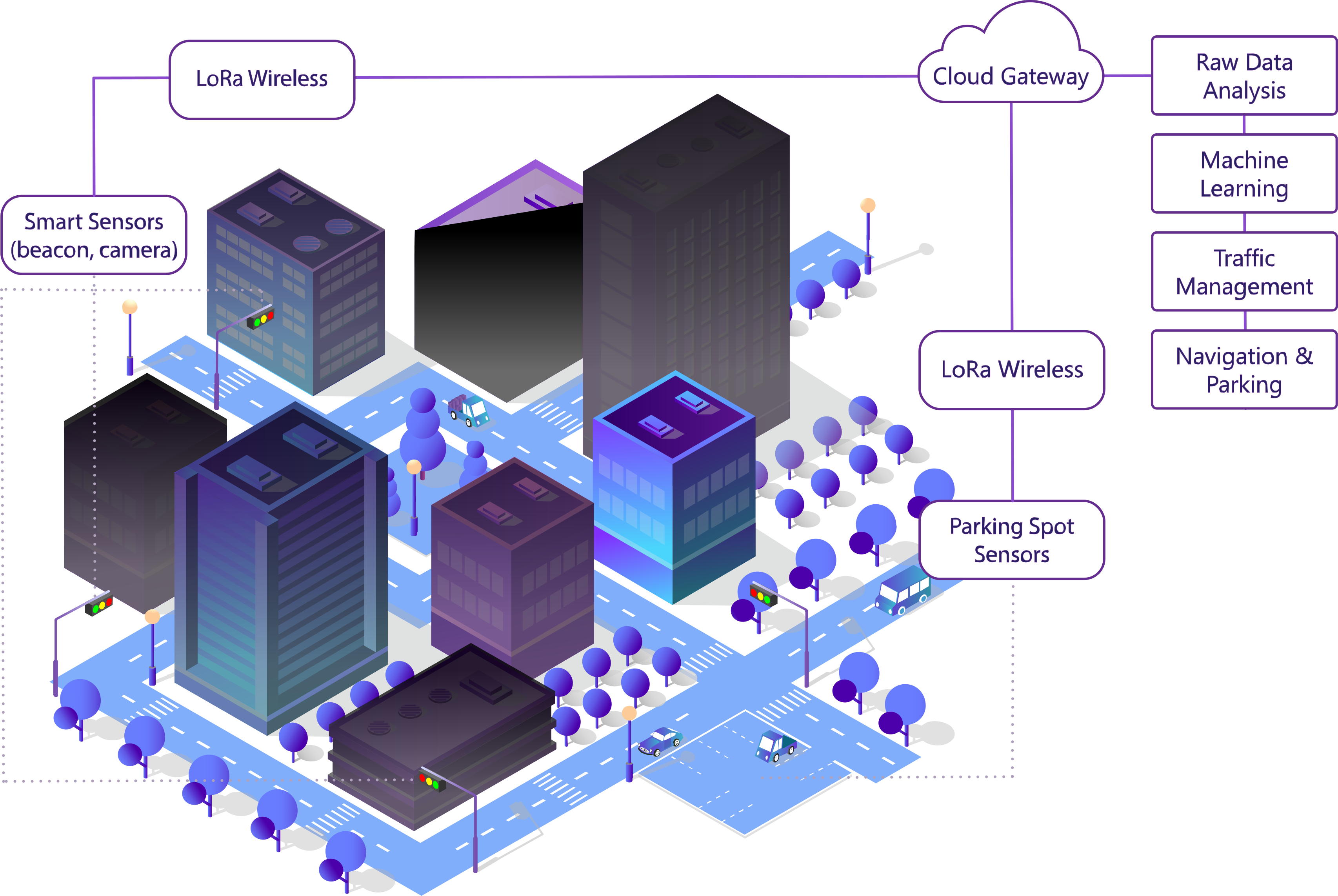
Data pipeline
01
LoRa Wireless Communication
LoRa base stations collect data from clusters of sensors — traffic detectors, parking bay sensors, and pedestrian counters — and forward it upstream over LoRaWAN, covering up to 5 km per base station without cellular infrastructure.
02
Cloud Data Platform
Telemetry from 20,000 devices streams into a scalable cloud ingestion layer that normalises formats, handles burst traffic, and routes events downstream in under 80 ms.
03
Raw Data Analysis
Real-time stream processing filters noise, aggregates vehicle counts per lane, detects anomalies such as broken sensors or accident blockages, and emits structured traffic snapshots every 10 seconds.
04
Machine Learning
Trained models forecast flow patterns 15 minutes ahead, identify recurrent congestion zones, predict parking demand by block, and surface optimisation opportunities for signal timing.
05
Intelligent Traffic Management
The central control engine adjusts signal plans in real time — extending greens on overloaded approaches, activating green-wave corridors, and balancing load across the network.
06
Navigation & Parking Intelligence
Drivers and navigation apps receive live congestion-free routing and real-time parking availability — the system guides vehicles to the nearest free spot, reducing circling traffic by up to 30%.
Smart parking & navigation
Live city map for drivers and operators
Every parking bay in the network reports occupancy in real time. The map updates as spots open and fill, and route guidance accounts for both current congestion and predicted parking availability at the destination — cutting average search time and reducing circling traffic by up to 30%.
City operators see the same map enriched with signal state, flow heat-maps, and fault queues — a single screen to manage the entire network.
- Real-time parking spot availability
- Routes to nearest free spot
- Predicted occupancy (ML-based)
- Traffic congestion overlay
- Signal state & fault queue
- iOS, Android & web dashboard
Key challenges
Reliability at city scale
With 20,000 nodes, even a 0.1% failure rate means 20 broken junctions. We built a self-healing mesh that reroutes telemetry through neighbouring nodes and pages an operator only when a device truly needs a site visit.
Real-time coordination
Green-wave corridors require signals to change in sub-second sequence across kilometres of road. We engineered an edge-compute layer that processes flow data locally and syncs to the central platform without waiting for a round-trip.
Legacy hardware integration
Many intersections already had proprietary controllers installed years earlier. We developed protocol adapters that let the new mesh layer communicate with older hardware without requiring a full hardware swap.
Technology stack
LoRa / LoRaWAN
Primary radio for inter-device telemetry over wide urban areas.
MQTT
Event streaming from edge gateways to the central platform.
Edge compute nodes
Local signal coordination — decisions happen in the field, not the cloud.
ML inference pipeline
Traffic pattern prediction and parking demand forecasting at scale.
Parking sensor network
Ultrasonic and vision-based detectors in each bay, updated in real time.
Live navigation API
Public API feeding congestion data and parking availability to navigation apps.
Building smart city infrastructure?
Whether it's traffic management, parking intelligence, or public utilities — we can design and deploy a mesh network at any scale.
Get in touch →